Our main objective is the creation of Engineering solutions as an added value in the olive grove sector through the use of Computer Graphics techniques and Geographic Information Technologies (TIG).
High technologies
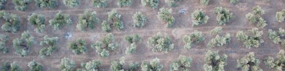
Information technologies, geographic information systems and artificial intelligence are the key in multiple sectors. On these technologies, and through the advanced use of drones to fly over farms to collect data for their subsequent analysis are supported the optimization models of the production and marketing systems, which help to make the best decisions.
The olive grove
The olive sector is not an exception, and currently the actors involved in this sector have to make decisions every day about the agricultural processes to be used, investments in the farms (fertilizer, cultivation, etc.) and, even more difficult, decide the best way of marketing the oil. This project helps in an important way for those responsible for the sector to make the best decisions in all production processes: farming, investment, production, harvesting and marketing.

Harvest Production Prediction
An early harvest prediction can be a key information to define a correct investment strategy for cultivation and marketing of past harvests. The price of olive oil depends in large part on the future harvest, since this determines that more or less liters are in circulation, in addition to that liters stored in the oil mills. This influences not only the price, but also the need for the oil mill have to sell the stored olive oil to free up its wine cellars and store the future olive oil, something that could occur if there is a large harvest. This last point has a negative impact on the price. A system that is capable of predicting early (around April or May) the future harvest, is key to choosing the correct marketing strategy.
Cultivation improvements
In the olive grove numerous repetitive tasks are carried out that require the mobilization and organization of technical and human resources (machinery, farm tools, workers, chemicals, etc.). These resources are normally mobilized and organized based on the experience of the owner or person in charge of organizing the work. In this project, simulation tools and algorithms are used to determine, depending on the size of the farm, its gradient, and its geographic location and the resources available on the farm, as well as the different configurations to indicate the best way to undertake the work.
The actors obtain the strategic information on which they base their own decisions
Farmer |
Oil mill managers |
Insurers |
|---|---|---|
|
Deciding on the investment to be made in its production (expansion of farm, improvements in irrigation, etc.) |
Deciding sales strategies |
Knowing the risk of the insured property |
| Deciding storage strategies | Calculating insurance premiums based on real risk |
Projects
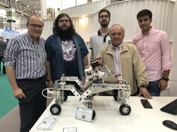
Oliver
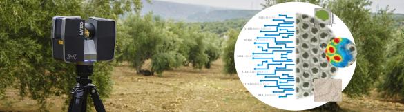
A robot is being developed with the objective to provide services in the olive grove sector. This way, the intention is to capture thermal, multispectral images and images in the visible spectrum as well as LiDAR data, always with the objective of defining a comprehensive database for each plantation. The processing and fusion of all this heterogeneous information enables the development of new methods to act against plagues in the olive grove, boost production and, in short, save costs to farmers.
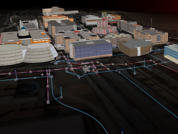
GIS 3D4D
The environment that surrounds us is three-dimensional and also changeable over time. The systems capable of modeling this reality must handle spatio-temporal data. This concept has been generally studied from the point of view of database systems, however, these information models are rarely implemented in applications where they are really needed. A couple of good examples where spatio-temporal management is very important are urban infrastructure and archeology. The problem in these fields of application is not only based in the possibility of handling the temporary variable. In both cases, the system needs to be able to carry out the complete cycle in the processing of this data. This includes capture on site or site, its treatment to be stored in the system, the management and analysis of these data, and in the archaeological case, also its dissemination. Therefore, we are talking about an integrated system, multipurpose when it comes to operating in situ or in the office, and also accessible to the agents involved in the process via the Internet.